Cargando...
Recursos educativos
-
Nivel educativo
-
Competencias
-
Tipología
-
Idioma
-
Tipo de medio
-
Tipo de actividad
-
Destinatarios
-
Tipo de audiencia
-
Creador
Lo más buscado
- Letras X
- Guía interactiva de minerales
- Actividades ángulos primaria
- Juegos educación física
- Ejemplo de descripción literaria
- imágenes matemáticas
- Actividades de lectoescritura en sexto
- Problemas de escalas
- fichas inglés
- Mapa conceptual del sistema endocrino
- William Shakespeare
- Relieve de Africa
- Operaciones de multiplicar
- Actividades de lógica en cuarto
- Arte gótico para noveno
-

Functions: Graphic representation
Sangakoo Organización
- 5428 visitas
Theory, examples and exercises of Functions: Graphic representation
-

Graphic representation of a function
Sangakoo Organización
- 2 lo usan
- 2082 visitas
Theory, examples and exercises of Graphic representation of a function
-

The representation of the Earth: maps
EduBook Organización
- 1 lo usan
- 5590 visitas
In the past, cartography (or map making) was a very slow process. It involved observation and complex calculations and drawings. Modern maps are made using aerial photos and images from satellites…
-

The representation of the Earth: maps
EduBook Organización
- 4154 visitas
2.1. Maps Maps are flat representations of the Earth's surface. To read and interpret a map we need to know its basic elements: scale and conventional signs. Scale Scale indicates how many times the…
-

Check. The representation of the Earth
EduBook Organización
- 1 lo usan
- 3733 visitas
Remember what you have learnt in this section and answer the questions: Why is it important to know a map's scale? What are the two types of map scale and how are they different? When are large…
-

Summaries - The representation of the Earth: maps
EduBook Organización
- 1 lo usan
- 3344 visitas
1. Latitude and longitude Geographical coordinates are imaginary horizontal and vertical lines that encircle the surface of the globe in a grid. There are two types: Parallels: hoirzontally encircle the…
-

Introduction - The representation of the Earth: maps
EduBook Organización
- 2496 visitas
In the past, cartography (or map making) was a very slow process. It involved observation and complex calculations and drawings. Modern maps are made using aerial photos and images from satellites…
-
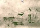
Representation of women in peninsular cave art
Maria Pallarés Docente
- 2 lo usan
- 2911 visitas
Representations of women in the Levantine cave art of the Iberian Peninsula. Details of cave art from Roca dels Moros (El Cogul, Catalonia) and Barranco de los Grajos (Murcia).
-
Think. The representation of the Earth
EduBook Organización
- 1 lo usan
- 1545 visitas
Think about how maps are made and answer: Why are satellites important tools for cartographers? What type of information do they provide? How do you think cartographers got this information before…
-
6. Self-evaluation - The representation of the Earth: maps
EduBook Organización
- 4847 visitas
Rewrite the sentences and correct the mistakes: In general, cartographers work with two types of map: physical maps and thematic maps. A road map is an example of a topographic map. Maps use…


Te estamos redirigiendo a la ficha del libro...
